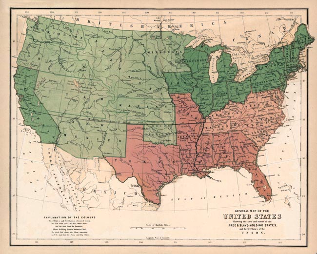
"Map of Free and Slave States."
The Slave Heritage Resource Center. 2008. Son of the South. http://www.bradley.edu/campusorg/psiphi/DS9/ep/503r.html.
Descriptions:
This is a map of the United States showing the free and slave states in 1857. The dark green states are the free states. The light green regions are the free territories - areas that are not yet states. The red states are the places where they import slaves. The pink states are the slave states that get their slaves from the red states.
Directions:
Directions:
The groups of dark green states are at the Northeast and there is one in the west. The light green regions are in the West center. The red states are in the Southeast and the pink states are in the east.
The dark green states were:
California, Iowa, Ohio, Wisconsin, Michigan, Pennsylvania, Maine, Vermont, Massachusetts, New Hampshire, Delaware, Rhode Island, New York, New Jersey, Maryland
The light green states were:
Washington, Oregon, New Mexico, Utah, Kansas, Nebraska, Minnesota, Oklahoma
The pink states were:
South Carolina, North Carolina, Tennessee, Kentucky, Virginia
The red states were:
Texas, Missouri, Arkansas, Mississippi, Florida, Georgia, Alabama, Louisiana
Conclusion:
The Civil war certainly changed this map since the red and pink states don't have anymore blacks who are called slaves. I included this map to show how the United States looked before the Civil War ended and out and got rid of slavery. In this map you can see that the slave and the free states are adjacent to one another. This tells us that slavery really divided up the nation. Since the slave states are close to one another, they can easily work together and seperate from the nation.
1 comment:
let's work on your analysis of this map...I'd like to see more connection in your paragraph. This is one post that can use some revising.
Post a Comment